Limi Valley Trekking

Limi Valley Trekking - 20 Days

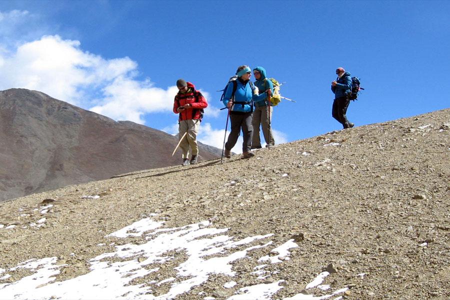
Limi valley Trekking also can be pronounced Simikot Limi Valley Trek follows The longest river of Nepal, Humla Karnali enters Nepal border at Hilsa where the Limi valley starts from West Side. The Trans Himalayan Limi valley trek is very beautiful, photogenic, wide and wonderful. Trek up to Gyuokharka (5150m) would be a life time experiences to see the spectacular views of Nepal’s Himalayas like Saipal (7031m), Byas Rishi, Api, Kanjirowa, Kanti, Gorakh Himalayas and Tibetan Himalayas like Mt. Kailash and Gorlamdanda and tranquil Mansarovar lake. This region is famous for rare flora and fauna. It can be seen the marmot, wolf, wild yak, blue sheep, wild horse (kyang), barking deer, musk deer, hare, Himalayan black bear and occasionally the snow leopard in this exotic region.

Indigenous Tibetan cultured people are settled there and they have their particular Tibetan language, tradition and culture. Very big and beautiful villages like Halji and Gombayok are located in the wide patches of Limi Khola. The limi valley trek is one of the perfect wilderness trek toward beaten track for every adventure lover.


Itinerary

Today you have free time until aiprot time, either shopping around around Thamel or walk around market. Our representative will drop off to airport for final departure to connect your flight to Home.

Meal
Breakfast
Accommodation
N/A

In the morning you will have flight from Simikot to Nepalgunj and in Day time or evening time you will have flight to Kathmandu. After your arrival in Kathmandu our office will host a farewell dinner for last night celebration among crews.

Meal
Breakfast, Lunch & Dinner
Accommodation
3 Star Hotel

Today you have free time until aiprot time, either shopping around around Thamel or walk around market. Our representative will drop off to airport for final departure to connect your flight to Home.

Meal
Breakfast
Accommodation
N/A

Our representative will welcome you at Airport and you will be dropped to the booked hotel.

Meal
N/A
Accommodation
3 Star Hotel

Today we have full day for Kathmandu sightseeing. We will visit most of all world heritage sites in Kathmandu such as bouddhanath, Pashupatinath, Patan, Darbar square, Swoyambhunath. Evening walk around market.

Meal
Breakfast
Accommodation
3 Star Hotel

Morning until 2 PM you are free on your own, In the evening we will depart for Nepalgunj by flight. Nepalgunj is lowland Terai region it is 500m from sea level. You will be dropped to hotel.
 

Meal
Breakfast & Dinner
Accommodation
3 star hotel

After landing in Simikot, at 2910m, the thing is lunch. Our 65-km trek to the Tibetan border begins by climbing from the Simikot air-strip, and passing by the water source for the upper Simikot Khasa village. Climbing the trail from here, we reach the Simikot Lagna Pass, at 3000 m. It does not look far, but it is a long 300-metre pul to the top of forested ridge overlooking the town. After decending for 1 hour the trail goes toward Darapori for overnight halt.

Meal
Breakfast, Lunch & Dinner
Accommodation
Camping

The trail this day starts off reasonably level. We pass by a Thakuri village called Tuling, and wild nut and apricot trees provide welcome shade along the bank of the River Karnali as the trek passes through Dharapori at 2300m. We cross the Yabka Khola (also known as Dhara-pori Khola), and soon We reach the campsite of Dharapori, which has a few teashops. Walking another 10 minutes brings us the Thakuri village of Dharapori situated on the top of a ridge which also has a police check-post. Below this village, a bridge over the Humla Karnali leads to a couple of Lama villages called Jad Kholsi and Khangalgaon. These villages belong to the Tugchulungba community and the route to these villages passes the Thakuri village of Hitan (thakuri) Kholsi. This is the last Thakuri village in the valley and the upper limit of rice cultivation. From Dharapori, the trail goes straight along the right bank of the Karnali River to the Gharapori Khola, a small tributary of the Karnali. Ascending from this stream of Dharapari Khola,the trail undulates along the Karnali River up to Chachera at 2350 m, a cave campsite used by sheep caravans. Thre is also nice waterfall nearby. Just above this waterfalls is a Lama village called Chyadog, which also belongs to the Tugchulungba community. Then climb over a ridge past swarms of lizards sunning themselves as we approach Kermi, situated besides a stream, at 2690 m. Kermi is the last Tugchulungba village.The actual route by passes Kermi and the only camp nearby is below the village.

Meal
Breakfast, Lunch & Dinner
Accommodation
Camping

This day, we begin by walking over a ridge to a big valley with walled potato and buckwheat fields, and climb through a sparse pine forest to a rock cairn on a ridge at 2900 m. This is the Salli Pass, where the trail meets up with the on from Limi. If we want to be proceed via Limi, turn right and follow the path into the jungle. Otherwise,descending steeply to the Tsongsa Khola (Salli Khola), We will cross a suspension bridge.After this, climb a steep rocky ridge and drop back towards the fast-flowing, light grey waters of the Humla Karnali.Climb over another ridge before descending to Yalbang Chaur, a meadow and goat herders' camp beside the river at 2760m. An annual barter trade between traders from Taklakot and the Humli people used to take place at this site in November. But, since the Taklakot people no longer face food shortages,they have stopped coming. From Yalbang Chaur, after climbing over two more ridges, We reach Yalbang village at 2890 m.From this village onwards to Yari, all villages belong to the community of the Yultsodum.Yalbang shares its hydroelectric power supply with its neighbour, Yangar,a few kilometers away. After a half-hour ascent from yalbang, We reach a newly built Nyingmapa monastery called Taglung Gompa or Yalbang Gompa at 3000 m, which has a good camping site.

Meal
Breakfast, Lunch & Dinner
Accommodation
Camping

From this monastery, walk straight for about 15 minutes until the trail branches into two alternative trails to Muchu. The route to the straight is the old route that follows a steep trail over a high ridge called Hilling La (pass) at 3500 m. From Hiling pass, we can see the beautiful valley of Muchu and Yari. This is one of the advantages of taking the upper route. From there, the route descends sharply to the Karnali River to reach a suspension bridge where we meet the newly built trail. Fortunately, we can now follow a new route, a lower path that avoids the climb. The newly built Yangar-Muchu trail passes through the compact settlement of Yanga, in some places going through tunnels beneath the houses, then climbs behind a rock spur to a fast –flowing stream. From there, the route descends smoothly to the bank of the Karnali River at 2770m. After walking along the river, with more than an hour of ups and downs, we reach a new suspension bridge, at 2800 m, which crosses over the Karnali below Muchu, where one meet the Hilling pass trail . After crossing the suspension bridge over the Karnali river ascend to a stream, rock-hop across it and climb past apricot orchards to a totally defunct Kangnyi, marking the entrance to Muchu village at 2920 m. In this village there is a gompa where the image of Jowo (Bodhisattva) Sakyamuni has been installed. The trail passes below the gompa and stone houses of Muchu. Climb through the orchards and fields of the village to a ridge, then drop into a ravine and climb to a chorten on the opposite side. There are a few houses on the ridge, and a border police post hidden just behind it. The ridge near the chorten offers a good view of the upper part of the valley and of Tumkot village and its large white gompa on the next ridge. At the foot of the gompa is Tumkot Khola, which,at 2850m, is our campsite.

Meal
Breakfast, Lunch & Dinner
Accommodation
Camping

We walk straight to Bungmachhe Khola (a tributary of the Karnali) at 2900m. There you cross a wooden bridge and the Humla Karnali disappears into a steep cleft northward behind the high ridge that will make you climb uphill for the next two days. The first part of the climb from the Bungmachine Khola is quite steep. The route enters a steep, rock-filled gully. It is a long, slow slog up to Lanang ridges at 3270m. The path levels out as it ascends to a cairn, at 3310m, then descends gently through juniper trees and climbs again to Palbang, with its single tea house at 3380m. Palbang, has a Nepali name, Pani Palbang. After walking straight for about an hour, we reach the teashop of Bhyagute Pani. From there, walking straight for about half an hour, we enter the villages of Yari. After Chang Ngoi village of Yari, you reach the customs office and check post, at 3670m, and ascending about 15 minutes, you reach the beautiful Zing Jyan campsite of Yari at 3750m. Then we acend a bit toward Thado dhunga to the base of Nara La Pass (4330m) for overnight halt.

Meal
Breakfast, Lunch & Dinner
Accommodation
Camping

Today we cross over the Nara La pass at 4530m. We trek up to pass is steep climb, the landscape looks more and more like Tibet. also we meet big caravans of mules, dzopkeys or yaks coming over the pass. We can see the view of Hilsa valley and Tibetan village Shera in the distance. At the north side of the pass, it looks like you are in Tibet. You are surrounded by barren mountains in many different colors. From the pass comes a long descent to Hilsa, which is the border with Tibet. 

Meal
Breakfast, Lunch & Dinner
Accommodation
Guest House / Caming

Once we leave Hilsa, crossing a suspension bridge. At the other side of the river, a small, a slightly difficult trail winds its way over a slope, until it connects with a larger trail high on the slope. We get 100meter close to the Chinese immigration buildings. This trail follows the Karnali River in eastern direction up till Manepeme. The path climbs gradually most part of the path is rocky. We walk in a dramatic landscape, where is a small flat area close to the huge Rock written Buddhist Mantra “OM MANE PADME HUM” the place is name after the Mantra. 

Meal
Breakfast, Lunch & Dinner
Accommodation
Camping

The trail leads inside thorny bushy zigzag till Chukrangma than climbs up very steeply for about half an hour to Lamka La, a pass at 4200m. After the pass, easy walk down to Til. We see some white buildings attached high to a slope. This is the monastery from Til with some retreat houses next to it. The village is surrounded by Himalayan red birches and terraced fields, which both are bright yellow in September-October. Til is a beautiful authentic Buddhist village, as are all villages in the Limi valley. Most villagers still wear the original Tibetan dress. We camp at a down below Til village, next to the river in Til Jyung. 

Meal
Breakfast, Lunch & Dinner
Accommodation
Camping

After breakfast at Till, we start our walk. Today we have a 3 hours easy walk to the village of Halji. The path follows the Limi River upstream and it is relatively flat walking. The trail offers a nice view and in addition, you can see some local animals including the snow leopard if you are lucky enough. Upon reaching Halji we see the Richening Gompa, built in the 14th Century. This is the central attraction of the Limi Valley because of its religious importance.

Meal
Breakfast, Lunch & Dinner
Accommodation
Camping

Today is also an easy walk from Halji to Jang’s Tashithang, following the Limi river. Jang is the one of three villages in the Limi valley and, as with the other villages, it is very special place where the Buddhist culture still continues relatively untouched by the modern world. We camp near the village place call Chekjur on the corner there is hot spring. You can enjoy bath in hot spring. Degung Kyapgon Rinpoche highest guru of Digung Kagyu bless the place and named it Tashithang. 

Meal
Breakfast, Lunch & Dinner
Accommodation
Camping

Today we will rest at Chegjur and take a bath at Chegjur hot spring and after Lunch we will have a drive to Lapcha Shyar toward the northern border side of Tibet/China, from where you could have a Mt. Kailash & Lake Manasarover respectively. After that we will a short drive back to the camp site.

Meal
Breakfast, Lunch & Dinner
Accommodation
Camping

The trail goes up slowly but gradually up toward Takchi bridge and enter to right side toward Zhabuk valley. From Takchi there another route leads north that is the way to Chhyakpalung and Lapcha Syar. From Lapcha Syar one can view Mount Kailash and Lake Manasarovar clearly. That is two days walk from Takchi river. Nowadays easily drive to Lapcha Syar and come back by truck in one day. From Takchi slowly walk toward Talung Tagkarbu via Zhabuk (Gonba Yok) ruined village. Zhabuk was biggest and most prosperous village before it ruins in Limi valley. Lama Palya is the richest one among the villagers. To save his mother, sister and wealth from enemy he had forcefully turned village into ashes, now you still see ashes turned it to white sand. Than continue toward Talung Tagkarbu via Tsomgo Lake. 

Meal
Breakfast, Lunch & Dinner
Accommodation
Camping

Today is a very tough, but rewarding climb to the highest point during the trek, the Nyalu La Pass 4950m. There can be snow, which makes the climb more challenging. From the pass we can see breathtaking 360 degree views into Humla and into Tibet. We can see the holy Mt. Kailash on nail size in far Tibet and Mt. Saipal 7031m and the many more mountains. From the pass it is a steep down will walk to the lake Seliman Tso at 4630m. The trail continues going down, following the Daramsala and enter to Tsongsa valley, to the campsite at Shinjungma. 

Meal
Breakfast, Lunch & Dinner
Accommodation
Camping

Today we follow the Sechi river toward Langdok La and climb up Langdok La Pass 4200m. From the pass we will have beautiful views of Sechi valley and surrounding peaks. The trail steep descends down to Takhor Khola and continues to Laga the summer house of Dinga village. 

Meal
Breakfast, Lunch & Dinner
Accommodation
Camping

Today we have easy trail up and down trail until simikot. 

Meal
Breakfast, Luncch and Dinner
Accommodation
Hotel

In the morning you will have flight from Simikot to Nepalgunj and in Day time or evening time you will have flight to Kathmandu. After your arrival in Kathmandu our office will host a farewell dinner for last night celebration among crews.

Meal
Breakfast
Accommodation
3 Star Hotel

What's Included?

  • Arrival and departure airport transfer
  • All necessary permits
  • Hotel with breakfast while in Kathmandu & Nepalgunj
  • Round trip Kathmandu - Nepalgunj - Simikot Flight fare
  • Camping and Kitchen crew
  • English speaking local guide
  • Mule and mule driver
  • All camping and kitchen equipments
  • Guided Sightseeing tours in Kathmandu
  • Freshly cooked full board meal during trekking
  • Insurance and expenses of Kitchen and camping crew and guide

Cost Excludes

  • Lunch and dinner in Kathmandu and Nepalgunj
  • Nepal visa
  • Access baggage charge
  • Travel insurance and personal expenses
  • Evacuation cost in case of emmergency.
  • Others which is not mentioned on the above included items

Equipment

Accomodation

You will be staying at 3 star hotel in Kathmandu & Nepalgun, If some one want to have higher category hotels, It is available on additional cost while in Kathmandu. We provide best reviewed and comfortable hotels in cities, you will love it for sure. Similarly we provide best camping tents during camping such as North face VE25 etc.

Meals 

It is included only breakfast (BB) while you are in Kathmandu and breakfast and dinner in Nepalgunj (MAP) Freshly cooked full board meal will be served during entire trip starting from Simikot. Our cook will serve you Indian, Nepalese, Tibetan, Continental and as well as Western food.

Recommended Clothing & Accessories

As the tempreture varies greatly between day and night (from Max. 20° celcius to Min. -10° celcius) one should prepare accordingly. As we believe in carbon neutral footprint "Maximum comfort with minimum items" are recommended. some recommendation for the trip are Woolen gloves, Balaclava, Sun hat, Thermal wear, Water bottle, Woolen sockes, Personal Towel, Light and Warm parka Jacket, Sunglasses, Sun Cream, Torch with extra batteries, Muffler, Mask, Raincoat, Sweater, T-Shirt, Sleeping bag and comfortable walking shoes etc.

Road Condition & Trekking Trail:

Simikot to Hilsa border 6 days trekking trail is good with gradual ascent visiting local villages and exploring Karnali rivers which helps to acclimatize your body to the elevation. There is now newly built track road available from Simikot to Hilsa border. After cheking in Tibet/China side roads are well maintained with paved road.

Altitude Problem & Physical Fitness

We Tibet Holidays lead our all trips smooth and pleasant however all tours/treks around Humla western Nepal go through above 4000m and it requires 5100m pass during Limi Valley trek along the way, It may occur some symptoms of AMS (Acute Mountain Sickness) such as headache, nausia, vomiting, loss of appetite & stomach disorder etc at the beginning once you enter Narala Pass (4800m), No worry as we have gradual ascend from Simikot, You could pass the Narala easily. We only suggest Participants with pre-existing medical conditions such as heart, lung, and blood diseases are required to consult with their doctor before taking the trip. There is no specific level of physical fitness is required, everyone could join on this tour/trek. It would be more helpful if you have previous trekking or hiking experience. Regular exercise, jugging, stretching and meditation or yoga for weeks or months before taking the trip would be good idea which enhance your body strength  and stability and also it helps to adjust your body to the elevation in a very short time. It is also advised that you inform Tibet Holidays team about your medical condition before booking the trip.. 

Acclimatization

This tour/trek may happen probability of AMS (Acute Mountain Sickness).  The higher altitude means the more less oxygen. For example, at an altitude above of 5000m, there is 50% less oxygen than at sea level. Therefore, our body needs some days to adjust in the elevation. This trip progresses with gradual ascent and does not reach a very high altitude in no time; We Tibet Holidays design all our program either with gradual accent or with some acclimatization days in order to avoid probability of AMS (Acute Mountain Sickness).

Best Time to Travel

The best time to travel Kailash is from March to Mid June in Spring and From September to November in Autumn will be best in order to get best views with sunny days while June, July & Agust may effect by rain as it covers mansoon season. Weather would be unpredictable in the region, Cloudy & Rainy would not remain for long time that is why you could even plan the trip in summer also.

Trip Start Dates and Cost

Private trip could take at any date while solo or individual traveler could check available trip start dates for Limi Valley Trekking on the Fix Departure section or Please contact us via email to join with group tours.

Reviews

Price USD 2390 2450

Make An Inquiry